Sandwich South Master Servicing Plan
Project web page last updated on May 8, 2025, to include a Natural Heritage Characterization Report. The final documents are available for review.
Master Plan Process Update
The Sandwich South Master Servicing Plan (SSMSP) has now been completed. On May 29, 2023, Council approved the issuance of the Notice of Commencement in accordance with the Municipal Class Environmental Assessment process. The SSMSP is now tabled for the 30-day review period. Interested persons may provide written comments to the project team by June 30, 2023. Please reference the Notice of Study Completion below:
Environmental Assessment Report (Completed)
The City of Windsor has completed the Class Environmental Assessment process for the Sandwich South Master Servicing Plan. You can access the report and appendices at the links below. To request a copy of the appendices in an Accessibility for Ontarians with Disabilities Act (AODA) compliant version, please contact Stacey McGuire at smcguire@citywindsor.ca noting the appendix being requested.
- Sandwich South Master Servicing Plan
- Sandwich South Master Servicing Plan - Appendix Figures (large file)
- Appendix A - Consultation Records
- Appendix B - Sandwich South Natural Heritage Characterization Report
- Appendix C - Archaeological Assessment
- Appendix D - Stormwater Management Report
- Appendix E - Sandwich South Transportation Report
- Appendix F - Sandwich South Municipal Functional Design Report
- Appendix G - Sandwich South Evaluation of Alternatives
- Appendix H - Sandwich South SWM Pond Design and Waterfowl Monitoring and Mitigation Plan
 What is this Master Plan All About?
The Sandwich South Master Servicing Plan outlines a long-term coordinated approach for municipal infrastructure in the Sandwich South area to support urbanization. The study developed and reviewed solutions for:
- Collector roads
- Water, sanitary and storm sewers
- Stormwater management facilities
The location and phasing of the proposed new infrastructure is outlined in the study.
Why a Servicing Master Plan?
 To meet the future growth needs of the city of Windsor, 2,600 hectares of land in the former township of Sandwich South were transferred from the Town of Tecumseh to the City of Windsor (City) in 2002. Sandwich South, which is located on the southeast side of Windsor is currently primarily rural but includes the Windsor Airport and some residential homes. The City has designated this area for future growth over the next 20 years and will include a variety of residential, commercial, institutional and industrial land uses.
The City initiated this master servicing plan for the Sandwich South area to develop a coordinated and sustainable approach to providing municipal infrastructure in support of growth.
Anticipated future growth will include a regional hospital that will serve the future healthcare needs of Windsor-Essex County. While the plans for the hospital have not been finalized, the master servicing plan is independent from this process and is a necessary step in a coordinated approach to planning and infrastructure for the entire Sandwich South area.
The plan considered the location and capacity of collector roads; storm and sanitary sewers; and how stormwater will be managed throughout the study area. The plan was prepared in coordination with a floodplain mapping study for the Little River Watershed. The floodplain mapping study has identified areas that may be susceptible to flooding during large storm events and guided the location of future development. The floodplain mapping study was completed and endorsed by the Essex Region Conservation Authority (ERCA) Board of Directors on May 10, 2023.
The study was conducted in accordance with the requirements of Phase 1 and 2 of the Municipal Class Environmental Assessment process (2000, as amended), which is an approved process under the Environmental Assessment Act.
Study Area
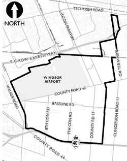
The Sandwich South study area for the servicing master plan involves 2,600 hectares of land, which generally spans from the E.C. Row Expressway in the north, Walker Road in the west, Highway 401 in the south, and Banwell Road in the east. The study area includes the County Road 42 Secondary Plan Area, and the East Pelton Secondary Plan Area. These two areas already have an existing secondary plan in place which will guide their development and land uses. The servicing master plan for the Sandwich South study area will work with the objectives of these plans. Lands outside the County Road 42 and East Pelton secondary plan areas will require secondary plans and servicing master plans prior to development in those areas.
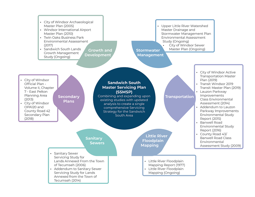
Integration with Other Studies

To view these full plans and studies, click on the documents below. Any ongoing studies will be made available when they are completed.
Growth and Development Studies and Plans
- City of Windsor Archaeological Master Plan (2005)
- Windsor International Airport Master Plan (2010)
- Twin Oaks Business Park Environmental Assessment (1997)
Sandwich South Lands Growth Management Study (ongoing)
Secondary Plans
Sanitary Sewer Studies
Little River Floodplain Mapping
- Little River Floodplain Mapping (2023)
Transportation Studies and Plans
Stormwater Management Plans
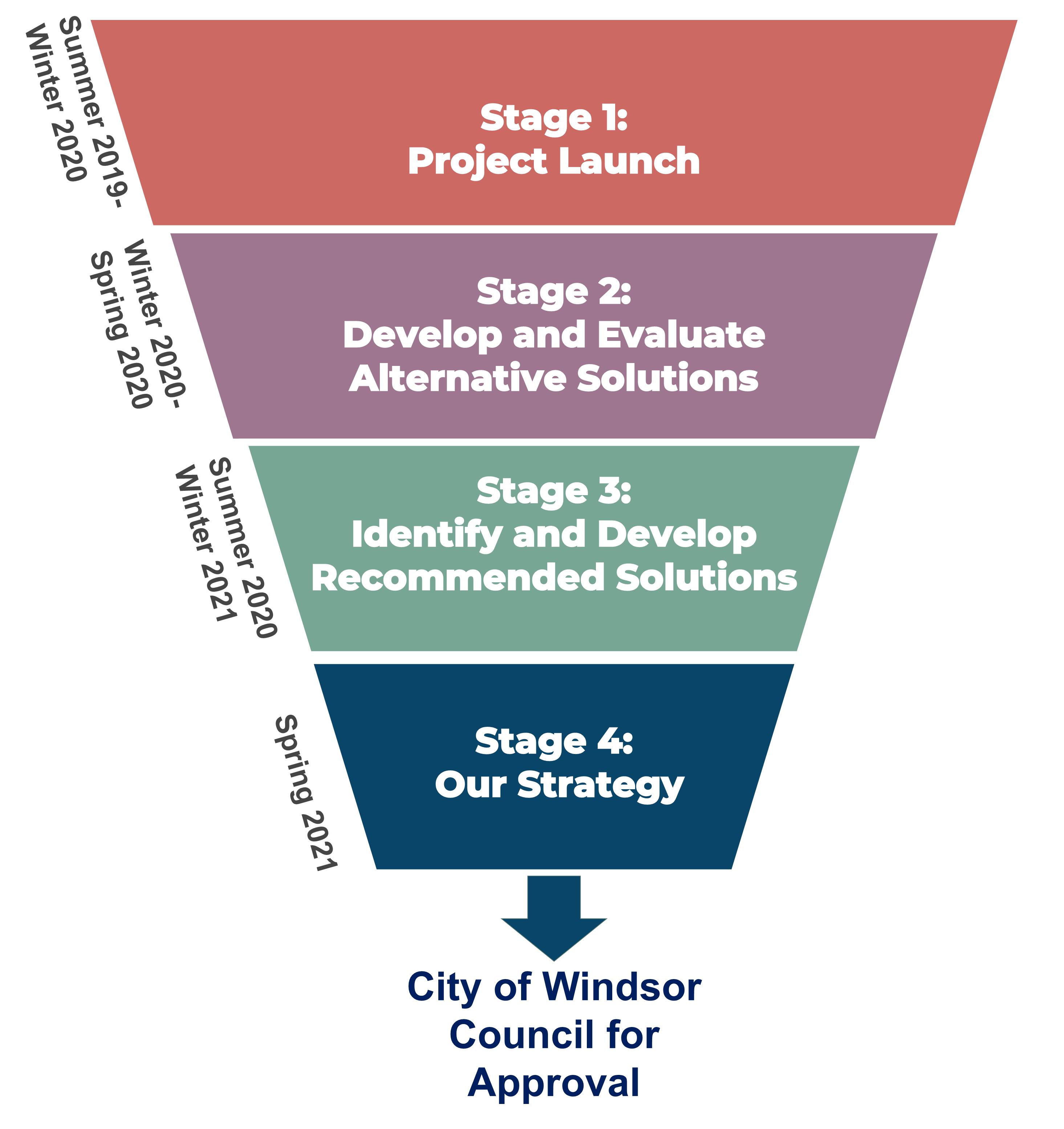
Project Timeline
Stage 1: Project Launch (Summer 2019 to Winter 2020)
- Establish study area and gather background mapping.
- Identify constraints and opportunities.
- Consult community on issues that matter.
- Host pop-up event.
Stage 2: Develop and Evaluate Alternative Solutions (Winter 2020 to Spring 2020)
- Consider road, sewer and storm options.
- Establish decision-making criteria.
- Identify potential impacts.
- Host Public Information Centre (PIC) #1.
Stage 3: Identify and Develop Recommended Solutions (Summer 2020 to Winter 2021)
- Review and incorporate feedback.
- Compare options considering feedback.
- Select preferred option.
- Host Public Information Centre (PIC) #2.
Stage 4: Our Strategy (Spring 2023)
- Review design options and finalize preferred designs.
- Prepare an overall strategy for Sandwich South servicing.
- Complete Environmental Assessment (EA) Reporting and Master Plan Document.
Public Engagement - To Date and Upcoming Opportunities to Get Involved
Stage 1: Project Launch (Completed)
- Notice of Commencement
- Issues and Opportunities Pop-up Event (Completed)
- January 30, 2020
- Pop-up-Event Display Boards
- Online Survey (Completed)
- Closed on March 25, 2020
A summary of what we heard from these Stage 1 engagement activities can be found in our Issues that Matter Report.
Stage 2: Develop and Evaluate Alternative Solutions (Completed)
- Stakeholder Advisory Committee (Completed)
- Meeting #1 occurred on July 27, 2020 (Summary of Stakeholder Advisory Committee (SAC) Meeting #1)
- Meeting #2 occurred on June 9, 2021 (Summary of Stakeholder Advisory Committee (SAC) Meeting #2)
- Public Information Centre (PIC) #1
- September 24, 2020 - October 31, 2020
- The information panels for PIC #1 are divided into 5 stations. Each station has an accompanying video that provides a run-through of the panels
- Station #1: Context
- Station #2: Existing Conditions
- Station #3: Transportation
- Station #4: Sanitary and Storm Sewers
- Station #5: Updated Floodplain Mapping and Stormwater Management
Summary of PIC #1 and Frequently Asked Questions provided by the public
Stage 3: Identify and Develop Recommended Solutions (Completed)
Public Information Centre (PIC) #2
Public Information Centre (PIC) #2
A PIC was held via Zoom from 5:00 p.m. to 7:00 p.m. on September 8, 2021, which consisted of an approximately 45-minute presentation followed by a 1-hour question and answer period.
Please also refer to the following:
Public Consultation: Sandwich South Master Servicing Plan - Additional Stormwater Management Assessment (June 2022)
Notice of Public Consultation - Additional Stormwater Management Assessment
Presentation - Comments period closed July 4, 2022.
- Additional Stormwater Management Assessment Presentation - Printable PDF
- Additional Stormwater Management Assessment - Video Recording of the Presentation
Please also refer to the following:
- Summary of Comparative Evaluation of Alternatives - Lauzon Parkway Stormwater Management Alternatives - June 2022
- Lauzon Parkway Stormwater Management Alternatives Figures
- Comment Survey
Public Consultation - Little River Watershed Regulatory Floodplain Mapping Update
A PIC was held virtually on November 17, 2021, from 6:00 p.m. to 8:00 p.m.
- Notice of Floodplain Mapping Public Information Centre
- Little River Watershed Regulatory Floodplain Mapping Update Study Presentation Material
- Video Recording of the November 17, 2021 PIC
The final floodplain mapping document was endorsed by the ERCA Board of Directors at their meeting May 10, 2023.
Follow the City of Windsor Social Media:
- Twitter: @CityWindsorON
- Facebook: @CityofWindsor
If you require additional information related to this study or wish to be added to the contact list, please contact:
Stacey McGuire, P. Eng. |
Andrea Winter, P. Eng. |
